


Spain Topo Maps

توضیحات Spain Topo Maps
+++ GPS برنامه نقشه برداری جدید +++
آسان برای استفاده از برنامه ناوبری GPS / بیرونی / آفلاین با دسترسی به بهترین نقشه های توپوگرافی و تصاویر هوایی برای اسپانیا.
از جمله جزایر بالئاری و جزایر قناری
++ برای آفلاین استفاده از PRO ویژگی های مورد نیاز! ++
آندوید تلفن / قرص خود را به یک GPS در فضای باز برای سفر به پشت صحنه بدون پوشش CELL تبدیل کنید. این برنامه به شما می دهد گزینه های نقشه برداری مشابه همانطور که شما ممکن است از دستگاه های دستی جیپیاس بدانید.
شامل لایه های نقشه رایگان:
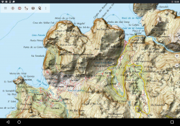
• اسپانیا Topo نقشه: Mapa Topográfico Nacional 1: 50.000 و 1: 25.000 (IGN MTN25 و MTN50)
• نقشه پایه IGN: Base Topográfica Nacional 1: 25.000 (BTN25 و BCN25)
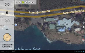
تصاویر اسپانیا: تصاویر هوایی با وضوح بالا. برنامه ملی آلفردوگرافی Area (PNOA)
• کاتالونیا نقشه Topo: نقشه های توپوگرافی با وضوح بالا برای کاتالونیا
• نقشه ثبت زمین: کارتوگرافی کاتاستار
• OpenStreetMaps: این نقشه های پر جمعیت، علاوه بر لایه های نقشه بسیار مفید است. شامل بسیاری از ویژگی های منحصر به فرد است.
• OpenCycleMaps: این نقشه ایده آل برای برنامه ریزی سفرهای دوچرخه است
• ESRI توپوگرافی
• تصاویر هوایی هوایی ESRI
• نقشه خیابان ESRI
• نقشه راه گوگل (فقط دسترسی به اینترنت)
• ماهواره های ماهواره ای Google (فقط دسترسی آنلاین)
• Google Terrain Map (فقط دسترسی آنلاین)
نقشه راه Bing (تنها دسترسی آنلاین)
• تصاوير ماهواره Bing (فقط به صورت رايگان)
• زمین در شب
• پوشش Hillshading
ویژگی های اصلی برای ناوبری در فضای باز:
• ایجاد و ویرایش نقطه راه
• GoTo-Waypoint-Navigation
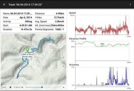
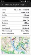
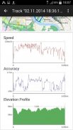
• ضبط آهنگ (با سرعت، ارتفاع و مشخصات دقت)
• Tripmaster با زمینه برای کیلومتر شمار اتومبیل، سرعت متوسط، تحمل، ارتفاع، و غیره
• صادرات GPX / KML / KMZ
• جستجوی (نام های جغرافیایی، POIs، خیابان ها)
• داده های قابل برنامه ریزی در نمای نقشه و Tripmaster (به عنوان مثال سرعت، فاصله، قطب نما، ...)
• به اشتراک گذاری راه های، آهنگ و یا مسیر (از طریق ایمیل، واتساپ، Dropbox، فیس بوک، ..)
• نمایش مختصات در Lat / Lon، UTM یا MGRS / USNG (شبکه نظامی / شبکه ملی ایالات متحده)
• ضبط و به اشتراک گذاری آهنگ با آمار و مشخصات ارتفاع
• چرخش نقشه (پیگیری و شمال بالا)
• با کلیک طولانی بر روی نقشه، ارتفاع را دریافت کنید
• پیگیری پخش
• و خیلی بیشتر ...
ویژگی های نرم افزار موجود: (ویژگی های نرم افزار از طریق خرید برنامه)
• استفاده آفلاین - بدون پوشش سلولی مورد نیاز است
• آسان + سریع فله-دانلود کاشی نقشه برای استفاده آفلاین (نه برای گوگل و نقشه های بینگ)
• ایجاد و ویرایش مسیرها
• مسیر یابی (ناوبری نقطه به نقطه)
• واردات GPX / KML / KMZ
• مسیرهای نامحدود و آهنگ
• اضافه کردن نقشه کاشی دیگر سرور
• بدون تبلیغات
استفاده آفلاین:
تمام کاشی های نقشه مشاهده شده در حافظه پنهان نگهداری می شوند. برای کشاندن مناطق بزرگ شما نیاز به خرید ویژگی های نرم افزار است.
از این برنامه ناوبری برای فعالیت های در فضای باز مانند پیاده روی، دوچرخه سواری، کمپینگ، کوهنوردی، سوارکاری، اسکی، قایقرانی، شکار، تورهای 4WD و یا جستجو و نجات (SAR) استفاده کنید.
نقطه های سفارشی سفارشی در طول جغرافیایی / عرض جغرافیایی، قالب UTM یا MGRS / USNG با ارقام WGS84 را اضافه کنید.
واردات / صادرات / به اشتراک گذاری نقاط GPS / مسیر / مسیر در GPX یا Google Earth فرمت KML / KMZ.
اطلاعات نقشه رایگان را برای مناطق بدون خدمات سلولی (ویژگی Pro!) پیش بارگیری کنید.
نظرات و درخواست های ویژگی به spainmaps@atlogis.com
نگاهی به سایر برنامه های ناوبری در فضای باز ما: https://play.google.com/store/search؟q=atlogis
+++ ما هیچ گونه فعالیت کاربر را دنبال نمیکنیم یا اطلاعات کاربر را جمعآوری میکنیم! +++
Spain Topo Maps - نسخه 7.8.0
(08-05-2025)
Spain Topo Maps - اطلاعات APK
نسخه APK: 7.8.0حزمة: com.atlogis.spainآخرین نسخه Spain Topo Maps
سایر نسخهها


 3.55
3.55


اپلیکیشنها در دسته مشابه


